|
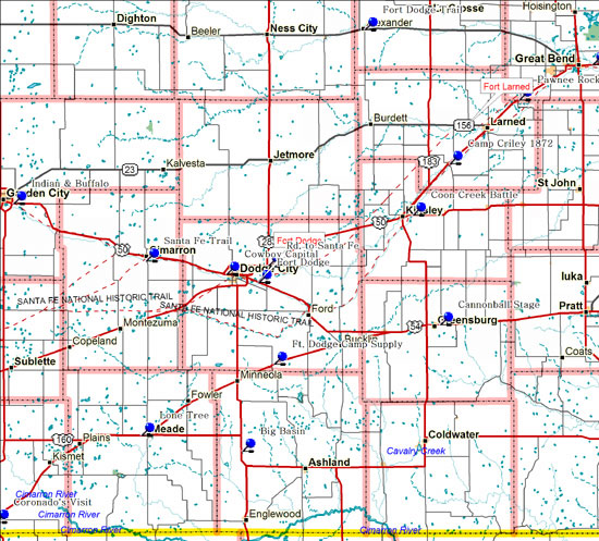
Marker Topic: Big Basin
Address: US-283,
15 miles south of Minneola, 3 miles south of US-160 junction
City: Minneola
County: Clark
Marker Text: The marker stands within a geological feature known as the Big Basin, which is a sinkhole or "sink" about a mile in diameter and more than a hundred feet deep. Although it has the appearance of a valley, it is entirely surrounded by higher ground. Like several other smaller sinks in this section of Kansas, Big Basin was formed thousands of years ago by dissolving and collapse of massive gypsum and salt formations lying several hundred feet below the surface.
Marker Topic: Camp Criley 1872
Address: US-56,
City Park in Garfield
City: Garfield
County: Pawnee
Marker Text: Camp Criley was established in 1872 as a supply station for workmen building the Santa Fe Railroad, named changed to Garfield in 1873 by pioneers settling here.
Marker Topic: Cannonball Stage Line Highway
Address: US-54,
Turnout east city limits of Greensburg
City: Greensburg
County: Kiowa
Marker Text:
Flamboyant and colorful, Donald R. "Cannon" Green (1839-1922) ran a stage-line connecting the railroad to towns across southwestern Kansas. Green started his first stage service in Kingman in 1876. It ran through Pratt to Coldwater and later to Greensburg, a town he helped found in 1886.
Marker Topic: Battle of Coon Creek
Address: US-50,
two miles east of Kinsley at Arkansas River bridge
City: Kinsley
County: Edwards County
Marker Text: Indian attacks along the Santa Fe Trail were frequent from the 1820s to the 1870s. Near here, where the trail followed the Arkansas River, the Battle of Coon Creek was fought June 18, 1848, between some 200 Comanches and Osages and 140 soldiers, half of whom were recruits bound for service in the Mexican War.
Marker Topic: When Coronado Came to Kansas
Address: US-54,
Jewel Avenue in City Park,
City: Liberal
County: Seward
Marker Text: Francisco Vasquez de Coronado, with 36 soldiers and Father Juan de Padilla, marched north from the Rio Grande valley in the spring of 1541. Coronado 's objective was the land of Quivira, described to the Spaniards as a fabulously wealthy kingdom where gold was commonplace. In June the expedition entered the Arkansas River to what is now Rice and McPherson counties. The Spaniards found no gold, only the grass lodges of the Quivira Indians, and the guide who misled Coronado was killed.
Dodge City - Cowboy Capital
Marker Topic: Dodge City - Cowboy Capital
Address: US-50 Business,
Roadside turnout, west of Dodge City
City: Dodge City
County: Ford
Marker Text: For ten years this was the largest cattle market in the world and for fifteen it was the wildest town on the American frontier. Established with the coming of the Santa Fe in 1872, Dodge City became the shipping center of the Southwest. The hunters who exterminated the buffalo here marketed several million dollars worth of hides and meat. Hundreds of wagon trains carried supplies to Western towns and army posts.
Marker Topic: Fort Dodge
Address: US-400 at site of fort, southeast of Dodge City
City: Dodge City
County: Ford
Marker Text: Fort Dodge, named for Major General Grenville M. Dodge, was established here in 1865. It was a supply depot and base of operations against warring Plains Indians. Custer, Sheridan, Miles, Hancock, "Wild Bill" Hickok, and "Buffalo Bill" Cody are figures in its history.
Marker Topic: Fort Dodge - Camp Supply Military Road
Address: US-54,
Rest area northeast of Bloom
City: Bloom
County: Ford
Marker Text: The Fort Dodge-Camp Supply military road passed several hundred feet west of this marker. The route was established in 1868 during General Philip H. Sheridan's winter campaign against Indians in Texas and the Indian Territory. This ungraded prairie trail, approximately 90 miles long, was important for transporting supplies from Fort Dodge and Dodge City to Camp (later Fort) Supply, in present Oklahoma, and was an important link in the communications system of western outposts.
Marker Topic: Fort Hays - Fort Dodge Trail
Address: K-96,
Rest area in Alexander
City: Alexander
County: Rush
Marker Text:
Established in 1867, the Fort Hays --Fort Dodge Trail, which passed near this spot, was first used by the military and some civilian traffic in 1868. The following year Alexander Harvey, a former member of the Sixth Cavalry, built a trading post on the trail on the north bank of Walnut Creek near here, and provided a place to ford the creek.
Marker Topic: Lone Tree Incident
Address: US-54,
Roadside turnout, 1 mile west of Meade
City: Meade
County: Meade
Marker Text:
During the first half of the 19th century the U.S. government, in response to public pressure for land and resources, began a program of concentrating Indian tribes on reservations. After the Civil War, an evergrowing number of settlers made it difficult for Native Americans to survive on the Plains. There was resistance from many Plains Indians, eventually resulting in open warfare.
Marker Topic: Road to Santa Fe
Address: US-56,
Roadside turnout, 8 miles east of Dodge City;
US-50 and US-283 junction
City: Dodge City
County: Ford County
Marker Text:
The Santa Fe Trail, extending 750 miles from the Kansas City area to the old Spanish settlement of Santa Fe, was the great overland trade route of the 1820s to 1870s. Its commercial use began in 1821, when William Becknell headed west with a pack train from Franklin, Missouri. For more than 500 miles the road lay in Kansas, angling southwest past such historic landmarks as Council Grove and Pawnee Rock.
Marker Topic: Santa Fe Trail
Address:
City Park
City: Cimmaron
County: Gray
Marker Text:
Cimarron, settled in 1878, got its name as the starting point at one time of the shorter Cimarron or dry route to Santa Fe. Here the Santa Fe Trail divided, one branch heading directly southwest, the other (present US-50) following the Arkansas River to Bent's Fort (near La Junta, Colorado), then south over Raton Pass. |
