|
||||
|
|
||||
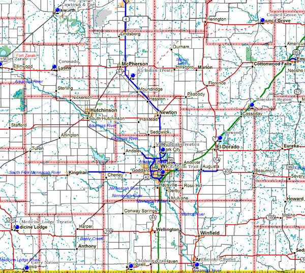
Bluestem RegionMarker Topic: Bluestem Pasture Region Caldwell and the Chisholm TrailMarker Topic: Caldwell and the Chisholm Trail Carry NationMarker Topic: Carry NationAddress: K-8, South edge of Kiowa City: Kiowa County: Barber Marker Text: Carry A. Nation, the militant crusader against illegal saloons, launched her career of saloon-smashing in Kiowa. She and her followers in Medicine Lodge, her hometown, had closed the local saloons by holding prayer meetings on their premises and displays of force. However, as the Women's Christian Temperance Union's jail evangelist, she found as many drunks as ever in the country jail. These men named Kiowa as their source of supply. Cherokee OutletMarker Topic: Opening of Cherokee OutletAddress: US-77, Roadside turnout, south of Arkansas City City: Arkansas City County: Cowley Marker Text: At noon on September 16, 1893 , more than 100,000 people lined the borders of the Cherokee Outlet listening for the pistol shots that started one of the world's greatest races. The prize was 8,000,000 acres of land: a quarter section or a town lot to every eligible settler who could stake a claim. Chisholm TrailMarker Topic: Chisholm TrailAddress: North Broadway, Roadside turnout, 2 miles north of I-235 City: Wichita County: Sedgwick County Marker Text: At the close of the Civil War when millions of longhorns were left on the plains of Texas without a market, the Union Pacific was building west across Kansas . Joseph McCoy, an Illinois stockman, believed these cattle could be herded over the prairies for shipment by rail. He built yards at Abilene and sent agents to notify the Texas cattlemen. The trail he suggested ran from the Red River to Abilene but took its name from Jesse Chisholm, an Indian trader, whose route lay between the North Canadian River and this vicinity. Council GroveMarker Topic: Council GroveAddress: US-56, Riverfront Park City: Council Grove County: Morris Marker Text: In 1825 growing traffic over the Santa Fe Trail brought a government survey and right-of-way treaties with certain Indians. Council Grove takes its name from an agreement made here that year with the Osage nation. Indians farther west continued their attacks on weak or unwary caravans. Indian Treaties 1865Marker Topic: Indian Treaties 1865Address: North Broadway, Roadside turnout, north of Kechi Road City: Park City County: Sedgwick Marker Text: In October 1865 hundreds of Plains Indians camped on these prairies to negotiate peace with U.S. government officials. Among them were Chiefs Black Kettle and Seven Bulls ( Cheyennes ), Little Raven and Big Mouth (Arapahos), Rising Sun and Horse's Back (Comanches), Poor Bear (Apache), and Satanta and Satank (Kiowas). Medicine Lodge Peace TreatiesMarker Topic: Medicine Lodge Peace TreatiesAddress: US-160, Memorial Peace Park 1 mile east of Medicine Lodge City: Medicine Lodge County: Barber County Marker Text: In October 1867, Iowa , Comanche, Arapahoe, Apache and Cheyenne Indians signed peace treaties with the Federal government. Fifteen thousand Indians camped nearby during the council, among them the famous chiefs Satanta, Little Raven and Black Kettle. Five hundred soldiers acted as escort for the U.S. commissioners. Towanda-Land of Many WatersMarker Topic: Towanda-Land of Many WatersAddress: I-35 (Kansas Turnpike), Milepost 76, Towanda service area City: Towanda County: Butler Marker Text: The town and township lie tucked in the pleasant valley of the Whitewater River , and take their name from the Osage Indian term "many waters." First settler was C.L. Chandler, a returning '49er from the California gold fields who built his cabin in 1858. Towanda township was one of the first four in the makeup of Butler County --the largest in Kansas . In 1870, Rev. Isaac Mooney, frontier preacher and community builder, platted ten acres for a townsite. The village quickly became a trade center on the Emporia-Wichita wagon road and a division point for two stage lines. Towanda gained wide fame in 1919, when giant oil gushers were drilled on rockey Shumway land at the town's eastern doorstep by Gypsy Oil Company and the Trapshooters group. Close neighbor is El Dorado , the county seat on the east, since pioneer days a prime adjunct to the Flint Hills cattle country and for more than 50 years the focal point of vast petroleum development in south-central Kansas . Its largest industries are modern oil refineries of Skelly Oil Company and American Petrofina, while the Butler County Community Junior College tops its cultural institutions. |
||||
|
||||
