Located adjacent to the major east-west trade route through Abo Pass, the Tompiro Pueblo of Abo (ca. 1300s-1670s) was one of the Southwest's largest Pueblo Indian villages. Extensive Indian house complexes are dominated by the unique buttressed walls, 40 feet high, of the Spanish Franciscan mission church of San Gregorio de Abo, built around 1630.
Spanish settlers had lived here before the Pueblo Revolt of 1680, but the area was resettled when the "Villa de Alburquerque" was founded in 1706. In addition to promoting colonization, the new town was intended to provide protection from attacks by Indians in Rio Abajo, or lower Rio Grande Valley.
By the mid-18th century, Spanish colonization had begun along the Rio Grande south of Albuquerque. The Belen land grant was made to encourage this expansion and colonists from Albuquerque settled here around 1740. The early community also included a group of genizaros, or Hispanicized Indians. Belen is Spanish for Bethlehem.
United States highway 85, which parallels Interstate 25 the length of New Mexico from Texas to Colorado, was designated "Dennis Chavez Highway" in 1988 to honor the long and meritorious service of New Mexico's first native-born United States Senator, Dennis Chavez (1888-1962). First elected to Congress in 1930, Chavez was serving his fifth consecutive term as United States Senator at the time of his death in 1962.
Incorporated in 1909 and county seat of Torrance County since 1905, Estancia is located in an enclosed valley or basin. It was ranching country until the early 20 th century, when the coming of the railroad opened it to homesteaders and farmers. Pinto beans were the best known local crop until the 1950s.
The Tompiro Indian "Pueblo de las Humanas" (ca.1300-1670s) had 1,500 to 2,000 inhabitants and was a trading center with Plains Indians. The village evolved for centuries on the fringe of the Mogollon and Anasazi cultures. There are two large Spanish Franciscan mission churches, San Isidro built in 1629, and San Buenaventura constructed in 1659.
Josiah Gregg, merchant and pioneer historian of the Santa Fe Trail, made four expeditions to Santa Fe. On his last, in 1839-40, he blazed a new route from Van Buren, Arkansas, which followed the Canadian River north of here. The new trail became popular with California-bound gold-seekers in 1849.
This large valley was occupied by ancient Ice Age Lake Estancia some 12,000 years ago. To the north, the Southern Rockies rise to altitudes of 13,000 feet; to the northwest are the Ortiz and San Pedro Mountains; to the west are the Sandia Mounains, and to the southwest are the Manzano Mountains.
Los Padillas is an extended family settlement which was resettled in 1718 by Diego de Padilla. His grandparents had lived on the site prior to the 1680 Pueblo Revolt at which time they were forced to abandon it. In the 1790 census the town, referred to as San Andres de los Padillas, had a population of 168. This is the site of the old Los Padillas School, originally built in 1901 and replaced in 1912.
Founded in 1902, Mountainair developed as a major center for pinto bean farming in the early 20th century until the drought of the 1940s. The region has been occupied earlier by Tompiro and eastern Tiwa pueblo Indians from prehistoric times through the mid-17th century, when it served as a major center for Spanish Franciscan missionaries.
Constructed in 1914, this building was designed by Atanacio Montoya, a progressive educator who introduced many reforms into early 20 th century rural schools. It served as the school for the Village of Armijo until 1948. This school incorporated architectural features that were considered quite innovative and advanced for its time and is the only surviving structure of its kind.

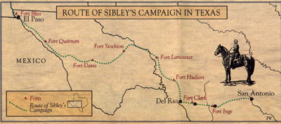
Texas Historical Commission

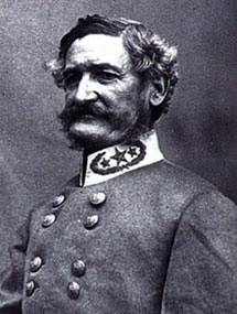
Gen. Henry H. Sibley
The Library of Congress
The center of Albuquerque's Old Town, the plaza dates from the early 18th century. San Felip de Neri Church was established in 1706, but construction of the present structure was begun in 1793. In March 1862, General Henry H. Sibley and his Texas volunteers occupied Albuquerque and raised the Confederate flag here.

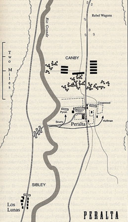
Map from the book, Blood & Treasure, by Donald S. Frazier
One of the last skirmishes of the Civil War in New Mexico took place here on April 15, 1862. The Sibley Brigade, retreating to Texas, camped at the hacienda of Governor Henry Connelly, a few miles from Peralta. Here the Confederates were routed by Union forces under Col. Edward R.S. Canby. More
Isleta, or "little island" in Spanish, is the largest of the Rio Grande pueblos. Many Isletans moved to El Paso with the Spanish during the 1680 Revolt; others resettled the pueblo around 1710. Parts of the missions, San Agustin de le Isleta, date from about 1613.
On the edge of the Plains stands the abandoned Tiwa Pueblo Indian village of Quarzi (ca 1200-1670's), the southernmost of the Tiwa villages, located along the eastern flanks of the Manzano Mountains. The Spanish Franciscan mission church of La Purisima Concepcion (1630) is the most complete remaining example of the large Salinas churches.
This unique regional complex of prehistoric Indian pueblos and associated 17th-century Franciscan mission ruins constitutes a "capsule in time" in which the first century of Native American-European contact in what is now the U.S. is preserved. Nearby are the Abo, Quarai, and Gran Quivira ruins. The central visitor center is in Mountainair's historic Shaffer Hotel.
This pass between the Sandia and Manzano Mountains has been a natural route for travel between eastern New Mexico and the Rio Grande Valley since prehistoric times. Known as Canon de Carnue in the Spanish colonial period, it takes its present name from the village of Tigeras, Spanish for "scissors".
In the fall of 1540, Francisco Vasquez de Coronado's army traveled from Zuni to his chosen winter headquarters in the Tiguex province on the Rio Grande. Here the advance guard of the army followed the river from the Isleta area to Alcanfor, a pueblo near Bernalillo, where it camped for two winters.
|


