|
||||||||
 |
 |
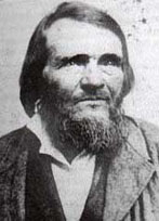
Daniel Parker Sr. |
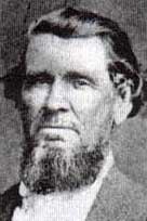
Abram Anglin, survivor of Parker's Fort Massacre |
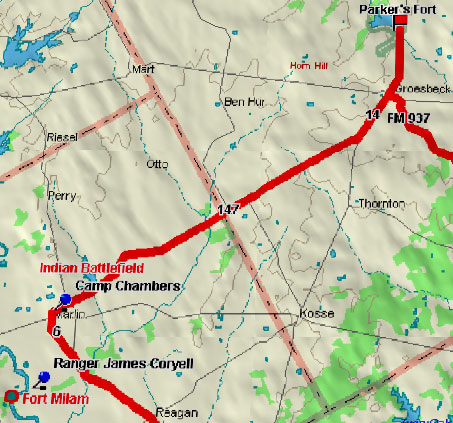
Marker Title: Fort Parker
Address: Of FM 1245, in Fort Parker Historical Park
City: Groesbeck
County: Limestone
Year Marker Erected: 1965
Marker Location: Fort Parker Historical Park, off SH 1245
on park rd. 35, N. of Groesbeck.
Marker Text: Built 1834 for protection from Indians. Named
for leaders who bought first Predestinarian Baptist church body to Texas:
Elder Daniel Parker; his father, Elder John; brothers Jas. W., Benjamin,
Silas, John. Also here were Kellogg, Frost, Nixon, Duty and Plummer
families on May 18, 1836, raiding Comanches killed Benjamin, John and
Silas Parker, Samuel and Robert Frost and others; captured Elizabeth
Kellogg, Rachel Plummer and son James, and Silas's children, John and
Cynthia Ann in captivity, Cynthia Ann married Chief Peta Nacona; her
son, Quanah, was last Comanche Chief. With her baby, Prairie Flower,
in 1860 she was captured by Texas Rangers. She, the baby and Quanah
are buried at Fort Sill.
Fort Parker Memorial Park Historical Marker
Marker Title: Fort Parker Memorial Park
Address: Off FM 1245, in Fort Parker Historical Park.
City: Groesbeck
County: Limestone
Year Marker Erected: 1964
Marker Location: Off FM 1245, on Park Rd. 35, Fort Parker
Historical Park, N. of Groesbeck
Marker Text:--
Old Fort Parker State Historic Site Historical Marker
Museum Name: Old Fort Parker State Historic Site
Mailing Address: Rt. 3 Box 746
Street Address: State Park Rd. 35
City: Groesbeck
Zip Code: 76642
Area Code: 254
Phone: 729-5253
County: Limestone
More on Parker's Fort
Home | Table of Contents | Forts | Road Trip Maps | Blood Trail Maps | Links | PX and Library | Contact Us | Mail Bag | Search | Intro | Upcoming Events | Reader's Road Trips Fort Tours Systems - Founded by Rick Steed |